Tennessee and Cumberland River Voyage
650 Miles from Chattanooga to Nashville TN
1500 Pictures taken; 317 to share with you
This page is brand new, so please send error
reports, comments and wise cracks
to
The trip overview
Driving a car from Chattanooga to Nashville is about 120 miles (about 2 hours). Driving a boat requires going through a total of four states: Tennessee, Kentucky, Alabama and Mississippi. It also required two rivers: the Tennessee and Cumberland. A few more miles on the Tennessee River would have taken us to Illinois.
The land along these rivers is mostly beautiful undeveloped land often with high sheer bluffs. The developed portions are mostly industrial which is why you see a a barge or two every day.
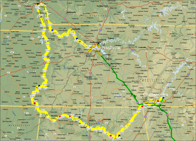
Map from Microsoft Streets and Trips
We passed through 9 locks and several small towns. Interestingly, the towns and cities often don't take full advantage of their waterfront. Even Nashville only has a few hundred feet of developed waterfront that is not industrial. There are a few residences and the rest is undeveloped. Even the water side of a major shopping area has no access for boats! Many restaurants whose land border the river literally turn their backs on the river. Perhaps this is due to restrictions from the TVA (Tennessee Valley Authority) but I suspect that the river is often regarded as an industrial transportation corridor and no more. There are many who don't know what they have in their own back yard.
The boat
We lived on our Adventurecraft boat for two weeks and all went well on the water. On the road, however, things were much different due to trailer brake lockup problems. We saw two other Adventurecraft boats in our travels, which is unusual. If you own an AC, then check out the adcraftowners area on Yahoo Groups for lots of advice and pictures.
One advantage this boat had over most other overnight-equipped boats was the ability to cruise in 2' of water and park in 1'. Try that in your 54' Sea Ray ;-)
I plan to post much more on this boat on a separate page. For example, it has a 40 gallon fuel tank that only dispenses 30 thanks to a short pickup tube, unusual shape and bad mounting angle. It will dispense more if you are under way, thanks to the angle change. This means that if you cruise past 30 gallons, it will keep running; but when you slow down to dock at a marina, it will stop supplying fuel and possibly make you crash into the dock. I installed a fuel management gauge to count how much fuel is used and avoid the grossly inaccurate analog fuel gauge.
The crew
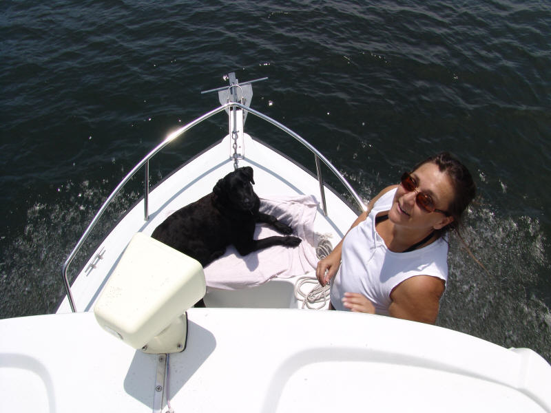
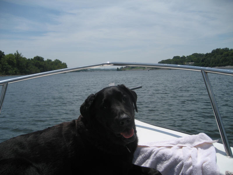
Scooby, our 9 year old lab mix, joined us on this trip so you will see many comments about how pet friendly some places are. For example, Rock City was very pet friendly and Scooby loved it. All marinas we visited welcomed pets but two had unusually long treks to get to the pet rest area.
Deb tends to the never-ending demands of our four-legged owner.
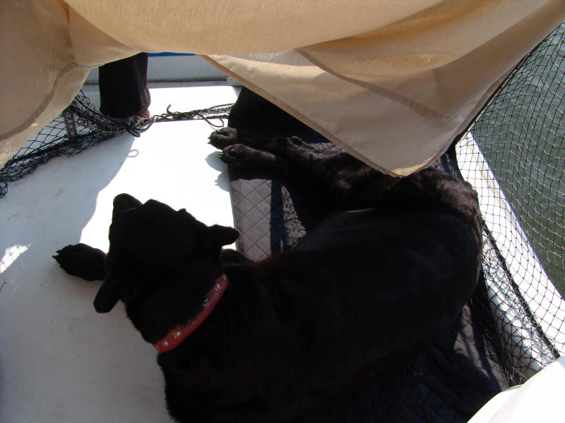
Those demands included being helped up a custom slanted ladder (just for him) so he could be up top with us. The netting is to be sure we don't lose him overboard and the sheet is for shade. Yes, the thermos of ice water is nearby.
He gets the bed when we have to leave... AC running full blast of course. Lucky dog. The glimmer in his eye? Lack of a lens due to cataract surgery. He can see about 5 - 10'.
The people
We met so many nice people along the way, especially fellow AC'ers (Adventurecraft owners). David and Sandra Fuller met us at the marina in Decatur & took Deb shopping for supplies; later they showed us around town & we had a nice dinner at the one & only riverfront restaurant in town. Our last night, at Rock Harbor Marina, we met Elisa and Alan Barr who are also ACers. They were using their AC as a second house full time!
The fun
- Not knowing what's around the corner; a bluff higher than you've ever seen? a small town you didn't expect? an unusual house? fish jumping? Deer crossing? All of those things happened and more!
Navigation
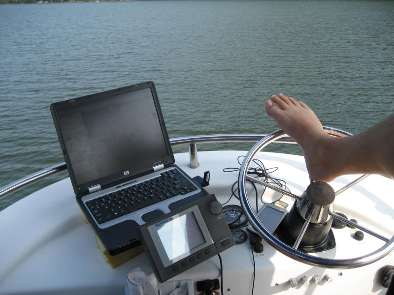
There are many maps available from the Army Corps web site but I recommend purchasing the printed charts. Even though I had a laptop on the fly bridge, it was easier to deal with the printed charts and it turned out the printed charts were newer! Mapsource charges too much for the same data and it won't track to my Garmin Ique GPS, so I used Google Earth and a USB GPS module to track where I am -live- as we go. The two information sources provide information that compliment each other.
The laptop, equipped with a Sprint Aircard for internet access and a USB GPS module, ran Google Earth Plus which tracked our position and let us see what is beyond the tree-lined banks. Below the laptop is a forward-scanning sonar and next to the wheel is a Garmin Ique GPS. Cruising at 15MPH in open waters didn't require full "hands-on" driving skills. The Aircard worked for over 90% of the river with only the small antenna you see. A larger cell antenna is mounted on the boat but it's used downstairs with our regular cell phones.
Follow Along! (new)
To follow along the journey with us:
1. Load Google Earth on your computer and launch it in a separate window (see "download" link on the left side).
2. Download the Tennessee River Placemark file and the Cumberland River Placemark file to your My Documents folder using these links:
Tennessee River Placemark file (RIGHT click, select "save target as" and save to My Documents folder)
Be sure it's saved as a .KML file. Some browsers want to save it as an .XML, which Google Earth will reject.
Cumberland River Placemark file (same here)
3. Select the Google Earth window and select FILE, OPEN, then look in My Documents for the files you downloaded and select one, load, then the other.
4. Look on the left hand side of Google Earth window to be sure there is a check mark by "Tennessee river" and "Cumberland river".
5. Zoom in on Tennessee and you should see a series of yellow markers in a shape similar to the river chart above.
Now you can see the various places marked on our map. Some were looked interesting during our planning but we didn't necessarily go to each one.
Reference material:
Army Corps maps for Cumberland River
Army Corps maps for Tennessee River
Marina list links: Tennessee1, Tennessee2, Alabama, Kentucky, Mississippi
We also brought an excellent reference for these rivers: "Cruising Guide to the Tennessee River, Tenn-Tom Waterway and Lower Tombigbee River" by Marina, Thomas and Rumsey
We also brought four Gazetteers by DeLorme mapping - one for each state: Alabama, Mississippi, Tennessee and Kentucky.
If you're looking for a much more brief but comprehensive source, get maps from Atlantic Mapping. They have one map for each lake, which means you'll need about 8 of them for the area we covered. We only had one for Lake Barkley
Microsoft Streets and trips (which also tracked with the USB GPS module, but only one program at a time can use it) was also helpful to find stores nearby.
The water levels
The water levels during this trip were unusually low due to drought.
IMPORTANT: when tying up for the night remember that the water level will likely be 1 to 2' lower the next morning. If you decide to beach the front of the boat at night, be sure to pull off shore just before turning in. The effect is greater just below a dam and far less just upstream from a dam. Why? These are hydroelectric dams that stop generating at night when there is less demand. When they stop generating, water stops flowing and the downstream level drops.
To be more precise, allow for 1 to 2' VERTICAL drop. This will translate into 5 to 15' (yes, fifteen feet) of shoreline. See xx island for 15' example.
We learned this lesson the hard way on the Chattahoochee River Trip. To save you some time, here are the pix:
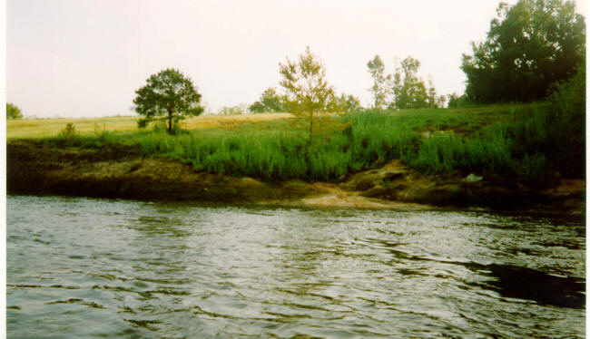
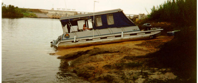
In 1995 we pulled our 29' pontoon boat up to the side of the Chattahoochee river just below the George Bagby dam and tied to that little tree by that patch of sand...
One hour later we return to find the water dropping past the point of flotation. This picture is TWO HOURS later; not even overnight! We did not see drops like this on the Tennessee or Cumberland rivers. We slept at this angle, slipping and sliding all night. Our dog and rabbit didn't seem to mind. The next morning water began to flow and we were on our way again.
We hope this picture sticks in your mind enough to remember: push off at night!
Peeves
- Campers who leave trash (especially glass) - I would love to see them caught and assigned to clean up 50 trashed camp sites as part of their community service. ...and maybe walk barefoot on some of that glass they leave.
- Marinas without pet areas near the docks. It's in their own best interest to encourage pets to do their business in one small nearby area, so marinas, please put even a small spot of grass near the docks. The hot pavement burns their feet! Putting it far away guarantees that much of the pet deposits will be well distributed outside the intended area. Those with hot pavement and long treks to pet areas: Birdsong and Perryville.
Day 1 - getting to Chattanooga
Day 2 Downtown Chattanooga, Mile TN-464
Day 3A - Downtown Chattanooga; Morning at Rock City
Day 3C Chattanooga - Evening - Aquariums (sorry, no pix, but be sure and see them when you're there!)
Day 4 - Hales Marina (gas), Nickajack lock, Crow Creek TN-401
Day 5 - Mill Hollow/Guntersville Dam TN-349.5
Day 6 - Decatur Alabama - Riverwalk marina
Day 7 - Wilson Lock, East Port, Florence
Day 8 - TN-246.5 Seven mile island beach
Day 12 - TN-62.7 - Fort Heiman Gravel beach
Day 13 - TN-25.5 - Gravel beach cove, Canal to Cumberland River, Green Turtle Cove Marina
Day 14 - CU-90, Lick Creek/Dover
Day 15 - CU-149.5 Cheatham Dam
Day 16 - CU-175.3 Rock Harbor Marina (near Nashville)
Day 17 - CU-216 Nashville, pull-out point just below the Old Hickory lock and dam
All photos and text Copyright 2007 Paul Kempter, except for the charts which are Army Corps and Google Earth pictures. They contain watermarks. Please give credit if you copy to your personal non-profit web site. High resolution copies of the photos are available for licensing (usually free to non-profit organizations).